

La página que intenta visitar sólo está disponible en inglés. ¡Disculpa!
The page you are about to visit is currently only available in English. Sorry!

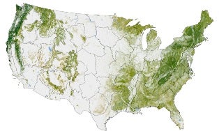 |
| Image: NASA Earth Observatory map by Robert Simmon, based on multiple data sets compiled and analyzed by the Woods Hole Research Center (click image to enlarge). |
A map of the 48 contiguous states offers a high-res and detailed look at our nation’s trees. The data is more than just a forest census, however. Trees may hold up to 45 percent of the planet's carbon, making this a detailed look at this country's organic carbon banks as well.
Josef Kellndorfer and Wayne Walker of Woods Hole Research Center put together the map, along with researchers from the US Forest Service and US Geological Survey. It incorporates radar, satellite, and computer model data collected over six years.
The map’s darkest greens represent the densest forests—such as the Pacific Northwest—while regions like the Great Plains appear virtually tree-less. The scale sets an acre to 4 computer display pixels.
Given a tree's role in managing carbon in our atmosphere, mapping woody biomass provides researchers with an important clue to the puzzle of how carbon cycles in our planet. It could also help answer questions like how trees can help manage human emissions and the consequences of a tree's death, which releases stored carbon right back into the atmosphere.
As Michele Wilson explains in a Perch post on creating a biomass benchmark, mapping biomass is an important first step in working out what happens to carbon.
For more on how forests, which cover 30 percent of the planet's surface, relate to carbon, don't miss NASA's Earth Observatory page, aptly titled "Seeing the Forests for the Trees."