

La página que intenta visitar sólo está disponible en inglés. ¡Disculpa!
The page you are about to visit is currently only available in English. Sorry!

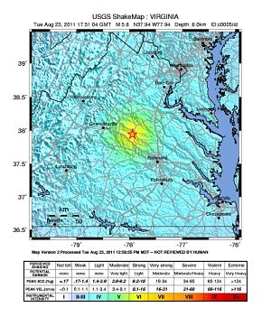 Shake map for Virginia earthquake, US Geological Survey |
Anyone on the East Coast—from DC up through New Hampshire, maybe even as far as Canada—this afternoon experienced what’s now being classified as a 5.8 magnitude earthquake.
“What’s that shaking?” one of my colleagues asked, as the table where we sat for lunch wobbled slightly.
“Must be someone shaking her leg,” I responded.
“It feels like an earthquake,” she remarked. No way, I thought.
Minutes later, a crowd of people gathered on the sidewalk outside our office building, rumbling about a Virginia epicenter and aftershocks up and down the eastern seaboard. It was an earthquake; it happened at 1:51:04 pm.
But the East Coast rarely experiences earthquakes, right?
According to the US Geological Survey (USGS), they occur more than we think—or feel. People in Virginia experience them once every year or two, in fact. “The largest damaging earthquake (magnitude 4.8) in the seismic zone occurred in 1875. Smaller earthquakes that cause little or no damage are felt each year or two,” states the Tectonic Summary for the Central Virginia Seismic Zone.
What makes East Coast quakes even more unique is the vast ground they touch, compared to those in the West. “Earthquakes in the central and eastern U.S., although less frequent than in the western U.S., are typically felt over a much broader region. East of the Rockies, an earthquake can be felt over an area as much as ten times larger than a similar magnitude earthquake on the west coast,” states the same USGS summary. It’s no wonder New York City apartment buildings were evacuated despite an epicenter hundreds of miles away.
So far, there have been no reports of injury or major damage, according to CNN.com.
If you felt the earthquake, let the USGS know here. (Even if you didn’t feel it, you can fill out the form. The USGS says the more information the agency gets for your ZIP code, the more reliable the average intensity assigned to your ZIP will be.)