

La página que intenta visitar sólo está disponible en inglés. ¡Disculpa!
The page you are about to visit is currently only available in English. Sorry!

|
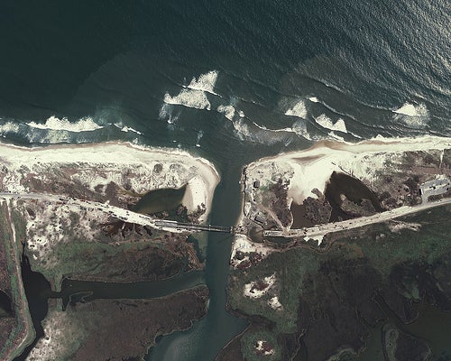
Progress of the Pea Island National Wildlife Refuge's temporary bridge being installed across the cut made by Hurricane Irene in 2011. Photo: North Carolina Department of Transportation/CC by 2.0 |
Storms like Sandy take from humans but give to birds.
“Birds depend on severe weather to help maintain habitat,” says Walker Golder, deputy director of Audubon North Carolina. “Historically, species like least and common terns and piping plovers that need early-successional habitat moved around wherever the habitat was best. And that habitat was created by storms—overwash fans, blowouts, erosion around inlets, shifting sandbars.”
No one is cheering Sandy. But it’s time to talk about habitat loss suffered by humans and birds that result from the vain attempt to contain the sea with artificial dunes, seawalls, and similar Maginot Lines against nature. Herewith, the most appalling example I know:
On a gusty summer afternoon in 2006 I found myself on North Carolina’s Outer Banks, trudging through the deeply rutted sand of Bodie Island on the north side of Oregon Inlet. With me was a noted ornithologist I’ll call “Mort” because if I use his real name, he’ll get more threats from folks who believe they should be able to drive off-road vehicles (ORVs) anywhere they please on Cape Hatteras National Seashore.
The spotting scope Mort toted, and the binoculars slung around my neck, sent a clear message to local motorheads that we were the “enemy”—i.e., birders. So they jeered and waved without using all their fingers.
Oregon Inlet hurls the waters of Pamlico Sound into the Atlantic, and in the process strips sand from 13-mile-long Pea Island National Wildlife Refuge to the south, shortening it by 10 to 15 feet every year and threatening the decrepit, 50-year old Bonner Bridge. An artificial dune runs the length of Pea Island, protecting Route 12 except during major storms, when waves bury and tear apart this hurricane evacuation route, the only access to and escape from Hatteras Island.
The fake dune, “beach renourishment,” and ceaseless road repair prevent sea-turtles from successfully nesting and ruin bird habitat by blocking regular overwash, removing storm overwash, replacing natural sand and the organisms it contains, and rendering the refuge a perpetual construction zone.
By the mid-1990s it was clear that a new bridge had to be built and not in the same place. Finally, in 2003, the year Hurricane Isabel demolished the fake dune and tore apart Route 12, the North Carolina Department of Transportation (NCDOT) announced that it would construct a longer bridge to bypass Pea Island because the current one was “no longer viable due to recent trends in shoreline erosion, ocean overwash of NC 12, and other changes in the setting of the project.”
Cost of building the long bridge: $425 million. Cost of replacing the short bridge and maintaining Route 12 through 2060: $620 million. NCDOT’S plan was a no brainer. The U.S. Fish and Wildlife Service, the Federal Highway Administration, and nine other state and federal agencies with related regulatory responsibilities backed the plan. So did the environmental community.
The long bridge would prevent ORVs from easily accessing Pea Island. Beach driving is prohibited on the refuge, but ORV operators have traditionally parked and walked to the fishing (something they have no problem with on the refuge but claim is an intolerable inconvenience on the national seashore).
So the motorized-access crowd hissed into the ears of Marc Basnight, then a state senator, and Stan White, then a Dare County Commissioner and NCDOT board member. Basnight and White, in turn, hissed into the ears of then Governor Michael Francis who hissed into the ears of then Interior Secretary Dirk Kempthorne. On July 5, 2006, Kempthorne proclaimed that the short bridge was the way to go, thereby undercutting his own Fish and Wildlife Service.
With that, NCDOT and the Federal Highway Administration flip-flopped, announcing a plan for replacing the short bridge. By doing so they violated the National Environmental Policy Act and the Department of Transportation Act, according to the Southern Environmental Law Center now representing Defenders of Wildlife and the National Wildlife Refuge Association in a lawsuit against the two agencies.
So storms have continued to buckle and bury asphalt on Pea Island—most recently on August 20, 2011, when Hurricane Irene tore away the fake dune, cutting two 200-foot-wide tidal rivers through Route 12 and on October 29, 2012, when Hurricane Sandy tore away the repaired dune, ripping out huge chunks of Route 12 and covering other parts with four feet of sand.
As of November 2012, Hatteras Island is again isolated from the mainland; and again motorists must depend on ferries until expensive and always temporary repairs can be made.
Nature has been telling us facts ORV advocates don’t want to know. They’re still committed to NCDOT’s short bridge and NCDOT’s regularly breached fake dune—“a monument to the stupidity of man,” to borrow George Patton’s designation of the Maginot Line.
Barely had Sandy blown itself out when Dare County motorheads, cut off from Pea Island and the mainland by the sea and their own folly, expressed outrage that birders arriving from the north for a major wildlife festival on the refuge called “Wings Over Water” (November 6-11) were not cut off. Warren Judge, chair of the Dare County Commissioners, publicly complained about the “irony” of the Fish and Wildlife Service allowing birders “to travel over the very bridge they advocate to remove!”
Wishing to avoid controversy, Wings Over Water organizers moved the event to Bodie Island.