

La página que intenta visitar sólo está disponible en inglés. ¡Disculpa!
The page you are about to visit is currently only available in English. Sorry!

 |
Many East Coasters are still reeling from hurricane Irene, which brought fierce winds and torrential downpours to the Atlantic seaboard this past weekend. The storm was just one of many hurricanes that impact American shores from June through November every year, yet despite their effects in the western hemisphere, they often form far away—from winds blowing off the coast of Africa.
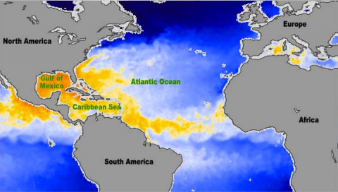
Along a route known as Hurricane Alley, warm ocean temperatures play a crucial role in strengthening storm systems from Africa to the Americas. The most common mechanism that leads to these hurricanes is the African easterly wave, “an area of disturbed weather that travels from east to west across the tropical Atlantic,” according to NASA’s Earth Observatory.
A jet of air forms when warm air from the Sahara Desert meets cool air from the Gulf of Guinea. The warm air rises and turns in a southern direction, making its way towards cooler air over the gulf. This current moves west (because of the rotation of the Earth) and is called the African Easterly Jet, say Steve Graham and Holli Riebeek, the authors of the NASA piece, titled "Hurricanes: The Greatest Storms on Earth." But sometimes a kink forms in the jet, and the air moves the opposite direction, creating what scientists call an easterly wave. “Converging winds on the east side of the easterly wave trigger the development of thunderstorms, and some of these large thunderstorm systems go on to become hurricanes. Most Atlantic hurricanes can be traced to easterly waves that form over Western Africa,” the article goes on to say.
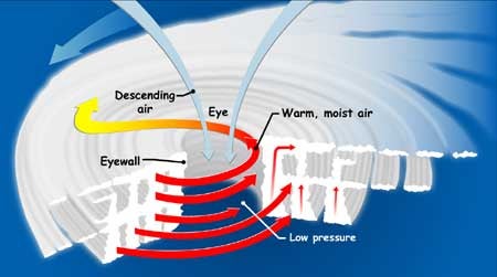
Hurricanes develop over warm ocean water where there’s a lot of humidity and light wind. There are a number of mechanisms by which these storms, technically called tropical cyclones, whirl into existence. As the wind moves across the ocean’s surface, water transforms into water vapor. This air rises and cools, condensing into water droplets and forming cumulonimbus clouds. Those clouds release heat, which rises and is then pulled into a cloud column. The column grows and wind starts flowing around it. As the clouds encounter other clouds, they form thunderstorm clouds. This is a tropical disturbance, the first stage of a hurricane.
As the cycle of evaporation, condensation, and column growth continues, the air at the column’s top warms as energy from the cooling water vapor rises. This increases air pressure and forces winds outward, away from the high-pressure zone. Meanwhile, pressure on the surface drops and the air moves to the low-pressure zones, where it rises and forms thunderstorms with the air moving from the high-pressure zone. As this is going on, the wind around the column circulates at an accelerating rate until, when it reaches a wind speed of 25 miles per hour, it’s called a tropical depression. When it reaches 39 miles per hour, it’s categorized as a tropical storm. And when winds whip around at a rate of 74 miles per hour, it’s classified as a hurricane.
 |
These storms are the most violent on the planet, say NASA and the National Ocean and Atmospheric Administration, and have been known as such for a long time. An ancient aboriginal tribe that originated in Central America, the Tainos, coined the term hurricane, which is named after their god of evil, Huracan. The storms are called other things in other parts of the world: typhoons in the western Pacific and China Sea; cyclones in Bangladesh, Pakistan, India, and Australia; and baguios in Philippines.
No matter what they’re called—or named—these storms are an unparalleled natural force. And hurricanes like Irene, and the havoc they wreak, are a reminder that they’re forces to be reckoned with.
For more on hurricanes, check out the National Weather Service's National Hurricane Center.